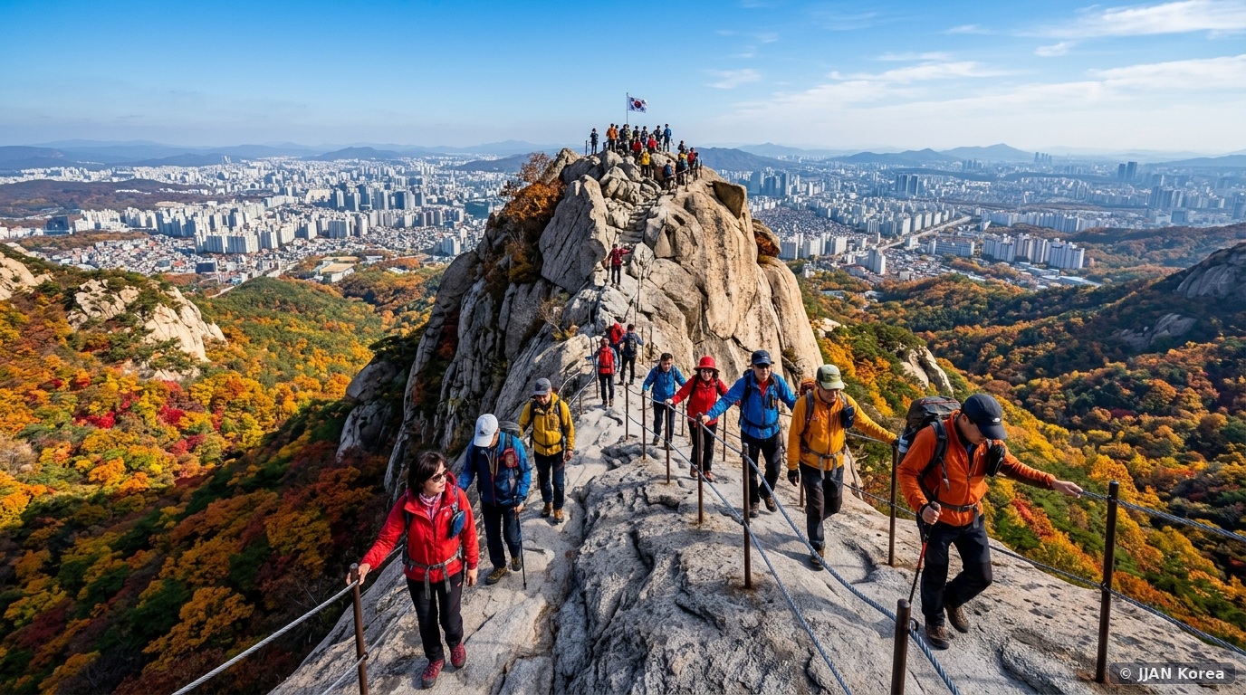
Few major global capitals on earth boast a majestic, untamed alpine mountain wilderness directly accessible via municipal public subway. Yet rising dramatically along the northern skyline of Seoul stands Bukhansan National Park (북한산국립공원)—a colossal granite massif designated by the Guinness World Records as the “Most Visited National Park per Unit Area.” While summer brings suffocating humidity, autumn—specifically the golden window between early October and early November—transforms Bukhansan into an exhilarating alpine paradise. The park’s highest granite apex, Baegundae Peak (백운대 – 836.5 meters), pierces the crisp autumn sky like a fortress of polished white stone, enveloped in a blazing sea of scarlet maples, yellow oaks, and fragrant Korean red pines. For active adventurers, scaling the steel wire safety cables up Baegundae’s bare granite dome rewards trekkers with a jaw-dropping 360-degree panoramic view sweeping across the entire Seoul metropolitan basin.
1. Trailhead Selection: Bukhansanseong Fortress vs. Ui-dong Route
Bukhansan spans over 78 square kilometers across northern Seoul and Gyeonggi Province. When targeting the summit of Baegundae Peak, hikers choose between two primary trailheads:
| Summit Hiking Trail | Subway Access Point | Distance to Peak | Estimated Time (One-Way) | Trail Character & Difficulty |
|---|---|---|---|---|
| Bukhansanseong Trail (West Entrance) | Line 3: Gupabal Station Exit 1 ➔ Bus 704 | 4.1 kilometers | 2.5 ~ 3.0 Hours | Gradual river valley, Joseon fortress gates, mountain temple stops; Recommended for first-timers |
| Baegundae Information Center (East Entrance) | Ui-LRT: Bukhansan Ui Station Exit 2 | 2.1 kilometers | 1.5 ~ 2.0 Hours | Steep, direct vertical stone stair ascent; fastest route to summit |
| Bibong Ridge Traverse (South Course) | Line 3: Bulgwang Station / Gyeongbokgung | 6.5 kilometers | 4.5 ~ 5.0 Hours | Strenuous ridgeline scrambling across exposed granite slabs |
While urban city wall walks provide gentle historical scenery, by graduating from beginner city wall hikes up to rugged alpine rocky trails, ascending Bukhansan introduces hikers to real alpine scrambling on polished granite rock faces.
2. Step-by-Step Route Guide: Bukhansanseong Course to Baegundae
The western Bukhansanseong course is the gold standard for panoramic beauty and manageable physical exertion:
- Stage 1: Valley Promenade to Daeseomun Gate (1.2 km): Beginning at the main Bukhansanseong Information Center, you walk along a shaded riverside path paved with flat stone pavers, passing through Daeseomun (대서문)—the majestic main western gate of the historic 18th-century stone fortress built to protect Joseon kings.
- Stage 2: Borisa Temple to Baegun Shelter (1.8 km): Crossing the wooden bridge at Borisa Temple, the trail transitions from gentle dirt into a steady, forested stone stair incline following the mountain gorge. Dense canopies of Japanese maples (Danpung) burn in brilliant orange and scarlet overhead. You will reach the historic Baegundae Mountain Rescue Shelter (Baegun Sanjang) at 650 meters, an ideal spot to catch your breath and hydrate.
- Stage 3: The Baegunbongammun Fortress Gate (0.6 km): Arrive at the narrow stone portal known as Wi-mun (위문 / Baegunbongammun Gate), perched between the towering spires of Mangyeongdae and Baegundae. The wind picks up dramatically here; put on your windbreaker shell.
- Stage 4: The Granite Wire Cable Ascent (The Final 300m): The grand finale. You emerge onto the bare, sheer granite dome of Baegundae. There is no dirt or vegetation here—only colossal white rock inclined at 45 degrees. Hikers grip heavy steel wire safety cables bolted into the bedrock while stepping onto metal foot rungs. Looking down between your boots reveals dizzying multi-hundred-meter vertical drops into the valley.
3. The Summit Milestone: The ROK Flag, Silla Stele & 360-Degree Panorama
Reaching the flat granite plateau of Baegundae Peak (836.5m) is an unforgettable emotional triumph. A stainless-steel flagpole flies the South Korean national flag (Taegeukgi), which whips vigorously in the crisp mountain wind. Hikers politely queue in single file to snap triumphant summit photos beside the inscribed bronze elevation marker.
From this elevated aerie, the panoramic view is astounding: to the south, the entire metropolis of Seoul unfolds—from the blue tile roofs of the Blue House and Gyeongbokgung Palace all the way south to N Seoul Tower, Lotte World Tower, and the gleaming ribbon of the Han River. To the north, the untamed jagged granite spires of Insubong Peak (810m)—famed worldwide as Korea’s premier traditional rock-climbing wall—rise like a monolith, where you can watch technical climbers scaling sheer vertical stone faces.
4. Critical Autumn Hiking Gear: Rubber Grips & Thermal Shells
Do NOT attempt to climb Bukhansan in smooth-soled street sneakers or fashion slip-ons. Bukhansan’s granite rock faces have been polished smooth by millions of rubber boot soles over decades, making bare rock slippery. Ensure your gear includes:
By choosing sturdy trail-running shoes and wind-blocking thermal gear, hiking shoes equipped with high-friction sticky rubber outsoles (such as Vibram Megagrip, Stealth, or Korean HyperGrip) are essential for biting into angled granite slabs. In addition, pack a pair of rubberized work gloves (or bicycle gloves) to protect your palms from blistering on the cold steel wire summit cables.
For sustenance, pack the classic Korean hiker’s trail lunch: a roll of foil-wrapped vegetable kimbap, sweet cherry tomatoes, and thermos flasks of hot water to prepare spicy instant cup noodles at the shelter.
5. Emergency 119 Rescue Post Coordinates, Hypothermia Prevention & Leave-No-Trace Rules
While Bukhansan National Park is seamlessly accessible by Seoul’s public subway network, Baegundae Peak sits at an alpine elevation of 836.5 meters and presents genuine mountain hazards, particularly during October when temperature inversions and sudden sunset cold fronts trigger rapid thermal drops. Hikers who ascend bathed in midday sunshine can experience sudden shivering, muscle cramping, and hypothermia once wind speeds pick up along the exposed granite ridges.
Throughout Bukhansan’s marked trails, the Korea National Park Service (KNPS) and the Seoul Metropolitan Fire & Disaster Headquarters maintain numbered yellow Mountain Emergency Location Signposts (San-ak Wi-chi Pyo-ji-pan) every 250 to 500 meters. These metal markers display specific alphanumeric codes (e.g., ‘Bukhansan 01-04’) alongside precise GPS coordinates. If you twist an ankle on uneven rock slabs or encounter an injured hiker, immediately dial 119 and quote the nearest post number. Paramedics and mountain rescue teams can locate your exact position within minutes without language miscommunication.
To guard against autumn hypothermia, always pack a lightweight windproof shell (windbreaker) and a packable micro-fleece in your backpack, even if city temperatures in downtown Seoul register a mild 20°C (68°F). Mountain ridgeline temperatures drop by roughly 0.65°C for every 100 meters of elevation gain, and summit wind chill can easily plunge perceived temperatures below 4°C (39°F). Swap sweat-soaked cotton base layers immediately for dry synthetic moisture-wicking shirts upon arriving at mountain shelters.
Finally, practice strict adherence to KNPS Leave-No-Trace regulations. In addition to the nationwide ban on mountain summit alcohol consumption, all national parks in South Korea operate a Green Point System (Green Point Jedo). Hikers who carry their own trash—including food wrappers, fruit peels, and beverage bottles—down to park ranger offices receive reward points redeemable for free national park shelter accommodations and regional camping passes. Do not leave food scraps behind, as they attract wild boars (Metdwaeji) that forage aggressively around autumn trails.
5. Frequently Asked Questions (FAQ)
Q1: Is there an admission fee to enter Bukhansan National Park?
No, entrance to Bukhansan National Park is 100% free of charge for all visitors. The park is open year-round from 04:00 AM until two hours before sunset.
Q2: Can I hike down a different route than the one I went up?
Yes, and it is highly recommended! The classic traverse is ascending via the western Bukhansanseong course (Gupabal Station side) and descending via the eastern Baegundae Information Center trail down to Bukhansan Ui Station on the Ui-Sinseol LRT line. This avoids repetitive scenery and drops you into a lively dining village filled with traditional Korean pancake (Pajeon) restaurants.
Q3: How dangerous is the steel wire cable section at the summit?
While the exposed height is intimidating for individuals with severe vertigo, the steel cables, welded stanchions, and metal footing rungs are inspected daily by National Park Rangers and are structurally rock-solid. As long as you maintain three points of contact, hold the cables firmly with both hands, and move patiently without rushing, it is completely safe for healthy adults and teens.
Q4: Is alcohol permitted on the mountain?
Under Article 28 of the Natural Parks Act, drinking alcohol (including soju and makgeolli) is strictly banned on designated mountain summits, shelter areas, and rock climbing routes across all Korean national parks. Park rangers conduct randomized breathalyzer patrols; violators face statutory fines of up to 100,000 KRW.
🛡️ JJAN Korea Editorial Standards & Fact-Checking Verification
This Bukhansan National Park alpine hiking guide has been authored and verified by Travel Editor Do-jun Kim following operational trail data published by the Korea National Park Service (KNPS).
- Summit route distances and safety infrastructure verified under KNPS Bukhansan Office Trail Safety Standards.
- Subway and municipal feeder bus connections confirmed via Seoul Metropolitan City Bus Transport Division.
- National park safety and alcohol restriction enforcement guidelines cross-checked under Natural Parks Act bylaws.