
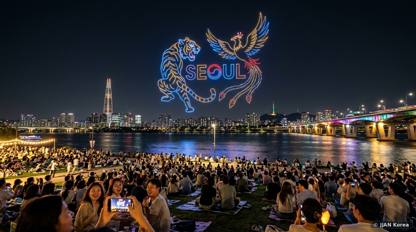
As twilight descends over Seoul and the futuristic skyscrapers of Jamsil illuminate the eastern horizon, thousands of spectators gather along the emerald lawns of Ttukseom Hangang Park (뚝섬한강공원). Suddenly, a collective gasp ripples through the crowd as a swarm of 1,000 to 1,200 illuminated LED quadcopter drones rises silently from a floating barge anchored in the middle of the Han River. Ascending into the ink-black night sky in military-grade precision formation, these airborne pixels twist, morph, and harmonize into colossal 3D glowing sculptures: traditional Korean dragons soaring above waves, holographic cityscapes, beating neon hearts, and poetic Hangul calligraphy stretching hundreds of meters across the sky. The Seoul Hangang Drone Light Show (한강 드론 라이트 쇼) has rapidly established itself as the capital’s premier free autumn spectacle, combining cutting-edge aeronautical robotics with Seoul’s beloved riverside picnic culture.
1. Performance Schedules, Themes & Autonomous Aviation Tech
Organized by the Seoul Metropolitan Government as part of the autumn Hangang River Festival, the drone light show takes place across selected Friday and Saturday evenings from late September through late October. Each performance lasts approximately 15 minutes, preceded by live indie busking, modern dance showcases, or orchestral performances along the riverside amphitheater stage.
| Event Element | Standard Operational Detail | Strategic Advice for Spectators |
|---|---|---|
| Primary Venue | Ttukseom Hangang Park Subyeon Stage (수변무대) | Subway Line 7: Jayang (Ttukseom Resort) Station Exit 2/3 |
| Performance Dates | Late September ~ Late October (Select Fridays/Saturdays) | Always check the official Seoul Tourism Portal for weather updates |
| Pre-Show Cultural Performances | 19:00 ~ 20:00 (K-Indie busking, classical brass) | Arrive by 17:30 to secure front-row lawn space |
| Main Drone Flight Window | 20:00 ~ 20:15 (Exact 15-Minute Flight) | Autonomous swarming drones ascend from river launch barge |
| Drone Fleet Size | 1,000 to 1,200 synchronized RTK-GPS quadcopters | Full 3D stereoscopic depth visible from perpendicular viewing angles |
| Admission Cost | 100% Free Public Admission | Open public lawn seating; no tickets or reservations required |
The technological sophistication of the show is breathtaking. Each drone operates with Real-Time Kinematic Global Positioning System (RTK-GPS) transponders accurate to within 1 centimeter. Centralized artificial intelligence ground control software dictates collision-avoidance algorithms while high-lumen multi-color RGB LEDs synchronize with a sweeping musical soundtrack broadcast through massive concert line-array speakers stationed along the river embankment.
2. The Strategic Viewing Zones: Front-Row Lawn vs. Crowd-Free Havens
Ttukseom Hangang Park stretches for miles, but the drones are angled toward a specific visual axis to ensure 3D depth and legible text orientation for viewers:
- Zone A: The Subyeon Amphitheater Lawn (Prime Front-Row): Directly facing the water barge stage, this terraced granite and grass amphitheater offers the absolute highest visual fidelity and direct sound immersion. However, it fills completely by 18:00. If you sit here, expect to be surrounded by thousands of picnickers.
- Zone B: The J-Bug Cultural Complex Promenade (Elevated View): Located just outside Exit 3 of Jayang Station, the unique cylindrical glass bridge known as the “J-Bug” (Seoul Thinkey) features elevated outdoor pedestrian walkways. This vantage point elevates you 10 meters above the grass, providing a spectacular composition capturing both the drone formations and the illuminated Cheongdam Bridge in the background.
- Zone C: East Grassy Lawns near Rose Garden (Relaxed Space): Heading 400 meters east toward the Ttukseom climbing wall reveals wide, open grassy lawns. While the musical soundtrack is slightly fainter, you enjoy abundant space to spread large picnic blankets without being jostled, and the elevated drone sculptures remain fully visible against the open sky.
- Zone D: The Southern Han River Detour (Cheongdam Hangang Park): For photographers seeking dramatic skyline photos without crowds, head across the river to Cheongdam Hangang Park on the south bank. Looking northward across the river, you view the glowing drones silhouetted directly in front of the illuminated DDP-inspired J-Bug complex and northern mountain peaks.
3. Mastering the Hangang Picnic: Instant Ramen, Fried Chicken & Mat Rentals
No trip to the drone light show is complete without indulging in South Korea’s iconic riverside culinary pastime: the Hangang picnic. By renting picnic mats and making instant noodles before the drone show, you participate in an authentic Seoul ritual that foreign travelers remember forever.
Directly outside Jayang Station Exits 2 and 3, dozens of independent rental shops offer “Hangang Picnic Packages” for approximately 15,000 to 25,000 KRW. These packages include a waterproof foam picnic mat, a low wooden folding table, cozy fleece blankets, a Bluetooth speaker, romantic battery-powered LED mood lanterns, and even reclining camp chairs loaded onto a compact folding handcart (Wagon). (Note: By municipal ordinance, shade tents must be dismantled by 19:00, but open picnic mats are permitted all night long).
For dinner, visit the riverside convenience stores to prepare foil-tray instant ramen (Hangang Ramyeon) cooked on automated induction boiling dispensers, or order piping-hot Korean fried chicken (Chimaek) delivered straight to designated riverside Delivery Zones (Baedal Zone – 배달존) using food delivery apps.
4. Post-Show Exit Tactics: Beating the Subway Stampede
The single greatest challenge of the drone show occurs at precisely 20:16 when the performance ends: approximately 25,000 people simultaneously surge toward the narrow turnstiles of Jayang Station (Subway Line 7), creating a 45-minute pedestrian bottleneck.
To avoid this stressful crush, implement these smart exit alternatives:
- Linger for 30 Minutes: Instead of immediately packing up, stay on your picnic mat for an extra half hour. Enjoy a final beer or dessert while the massive initial crowd drains from the park.
- Walk to Konkuk University Station (Line 2/7): Instead of entering Jayang Station, embark on a pleasant 15-minute walk north along Neungdong-ro toward Konkuk University Station (Geondae). You bypass the entire station jam and emerge directly into one of Seoul’s liveliest youth nightlife and dining districts.
- Grab a Public Bicycle (Ttareungyi): By cycling along Ttukseom riverside bike paths to beat post-show subway rushes, you can unlock a city bicycle from designated docking stations and glide smoothly along car-free riverside bike paths west toward Seongsu-dong or east toward Gwangnaru.
5. Smartphone Camera Settings & Jayang-dong Lamb Skewer Alley
Photographing fast-shifting 3D illuminated drone formations against a pitch-black river backdrop requires tweaking standard smartphone camera algorithms. Night Mode automatically extends exposure times to 3 or 4 seconds; however, because individual drones are in continuous flight motion, prolonged exposures blur intricate calligraphy and sharp geometry. Turn Night Mode OFF. Instead, lock your smartphone exposure focus directly onto the glowing formation, pull the yellow exposure brightness slider downward by 30% to prevent blown-out neon highlights, and shoot in rapid burst mode or 4K 60fps video.
After the show concludes and the crowds begin dispersing, take an 8-minute walk from Exit 5 of Konkuk University Station into the vibrant Jayang-dong Lamb Skewer Alley (Geondae Yang-kkochi-gil – 건대 양꼬치거리). This bustling international culinary corridor is packed with over 80 specialty restaurants serving cumin-spiced charcoal lamb skewers, crispy sweet-and-sour pork slices (Guobaorou), and icy draft beer, providing an electric post-show dining feast open late into the night.
Insiders’ Ttukseom Audio Strategy: If you find yourself seated on the peripheral lawns further east near the Han River Rose Gardens where the central speaker system is less audible, tune your smartphone to the official Seoul City YouTube or AfreecaTV live broadcast stream using Bluetooth earbuds. The municipal stream broadcasts the exact synchronized concert musical score in lossless high-definition stereo, providing personal acoustic immersion without missing a single orchestral crescendo.
5. Frequently Asked Questions (FAQ)
Q1: What happens if it rains or there are strong winds?
Quadcopter drones are sensitive to adverse meteorological conditions. If sustained wind speeds exceed 8 meters per second or if moderate rainfall begins, the Seoul Metropolitan Government will cancel or postpone the performance for flight safety. Official real-time status updates are posted on the official Instagram page (@hangang_drone_light_show) and the VisitSeoul official tourism portal by 17:00 on the day of the show.
Q2: Are private consumer drones allowed to fly during the show?
Strictly NO. The airspace surrounding Ttukseom Hangang Park is designated as a strict No-Fly Temporary Restricted Airspace (Cho-keo-rim Gong-yeok) under the Aviation Safety Act during the event. Operating private consumer drones (DJI, Autel) risks severe federal criminal prosecution, confiscation of equipment, and fines up to 5,000,000 KRW.
Q3: Are public restrooms available in the park?
Yes, Ttukseom Park maintains numerous modern, heated public restrooms situated every 200 to 300 meters along the promenade. However, lines for women’s restrooms can become lengthy during the 30 minutes leading up to showtime; visit the facilities inside the subway station or J-Bug building before finding your lawn spot.
Q4: Can I bring my dog to watch the drone show?
Yes, pets are fully welcome on the open grass lawns of Hangang parks, provided dogs remain on a standard non-retractable leash (maximum 2 meters) and owners carry waste disposal bags. However, be aware that sudden cheers and booming musical soundtracks can startle sound-sensitive pets.
🛡️ JJAN Korea Editorial Standards & Fact-Checking Verification
This Seoul Hangang Drone Light Show spectator guide has been authored and verified by Culture Editor Min-ah Kim in coordination with event production directives released by the Seoul Metropolitan Government Hanang Project Headquarters.
- Performance schedules and weather contingency protocols cross-referenced with Seoul Tourism Organization bulletins.
- Airspace safety restrictions and no-fly zone boundaries verified with the Ministry of Land, Infrastructure and Transport (MOLIT).
- Public park camping ordinances audited under Seoul Metropolitan Government Hangang Park Management Bylaws.